- Daily & Weekly newsletters
- Buy & download The Bulletin
- Comment on our articles
Related articles
Recent


Popular

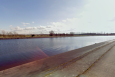
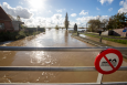
Flood inquiry hears how multiple warnings went unheeded
")
Could the Belgian authorities have predicted the July floods and anticipated the scale of the disaster? According to a report from the European Flood Awareness System (Efas), the weather forecast for the period should have been alarming enough for the authorities to react and that warnings had been issued four days before the tragedy.
These revelations prompted questions from the Committee of Inquiry in the Walloon parliament on Friday when David Dehenauw, head of forecasting at the Royal Meteorological Institute of Belgium (RMI), and Philippe Dierickx, director of hydrological management (DGH) within Walloon public service, attended the hearing.
The committee, which is investigating the reaction of the authorities to the July floods, referred directly to the Efas notifications, which provide predictive models to help manage floods, during the questioning. Dierickx confirmed that the DGH had not been connected to this system and had not consulted the data due to a lack of training among its engineers. He admitted that the DGH still has to test the Efas system before integrating it into its routines.
"Efas is a tool that is not yet operationally used in our circuit, because we have not been able to validate it,” he told the committee. “We do not necessarily always have positive feedback. It is extremely complicated to interpret."
Committee member François Desquesnes, head of the CDH group in the Walloon parliament, revealed during the hearing that that warnings of catastrophic floods in the Vesdre and Ourthe basins in Wallonia had been issued at noon on Monday 12 July.
"Efas notifications are available to the public 30 or 40 days after they are issued,” he said. “We consulted them, and it appears that as early as 12 July at noon, the flood warnings were clear. The questions we ask ourselves are, what has the Walloon region done with this information? What alerts have been given? Who was warned in the hierarchy? Was Minister Philippe Henry warned? Had the regional rescue centre been activated? Why had the emergency services not been put on standby? Why hadn’t the population been alerted?
“The region defends itself by claiming that the information was not precise. But when we look at the maps, we see that it was extremely accurate 48 hours before the floods. Why didn't we take stock of what was going to happen?
"Contrary to what has been said, there is detailed and accurate information that identifies almost to the nearest square kilometre where the flood will be most catastrophic. This information was not used in time, and we would like to understand why."
The Royal Meteorological Institute of Belgium’s David Dehenauw also told the committee that several models were already predicting huge quantities of rain for 14 July, with between 100 and 150mm expected in some areas, and that the institute had made its own information available on 12 July.
"What normally falls in two months was going to fall in two days,” he said. “This was very clear in the data seen by our specialists. I was convinced that something serious was going to happen."
When asked why a red alert had not been issued, it was revealed that the lack of one was down to the RMI alert deadlines. A yellow alert can be issued 48 hours before the event, an orange alert 24 hours before the event and a red alert 12 hours before the event.
It was therefore necessary to wait until 14 July at 9.00 for a red alert to be issued, even after significant rainfall of 100mm from Saturday 10 July at noon and 150mm from Sunday 11 July at midnight had been forecasted.
In relation to the floods that followed, Dehenauw added that the Institute could anticipate the time of the rainfall but not its impact. “We don’t have those skills,” he admitted. “Evaluating this impact is another profession." He concluded that closer collaboration with the DGH would be needed to avert future disasters.
The previous day, on Thursday of last week, the Committee heard from Xavier Fettweis, the director of the climatology laboratory at the University of Liège, who also revealed that all their models at the time had pointed to extreme weather in the Ardennes.
“At midnight on Monday 12 July, all the models said the same thing,” he said. “We knew that we were going to be faced with an extreme rainy episode in the Ardennes and that there would be floods.”
Fettweis compared the situation in mid-July with what happened in September 1998. At that time, rainfall of 100mm had caused flooding. Therefore, with forecast models expecting more than 100mm of rain to fall in the days from 10 July, flooding should have been expected.
He added that episodes of this magnitude are expected to increase over the coming years.
"The different scenarios presented by the Intergovernmental Panel on Climate Change suggest a multiplication of this type of bad weather in the next 10 to 30 years," said Fettweis. Three out of four climate models suggest events similar to that of last July will take place during the 2030s.